
Wildfire Ready
We Live in Fire Country, and We're In This Together
Our mountain views, open spaces, and canyon trails make Boulder County an incredible place to call home. They're also why wildfire is part of our reality. The Marshall Fire reminded us how quickly things can change, but it also showed us something powerful: when we prepare together, we protect each other.
Many homes still need defensible space work. Whether you've lived here for decades or just unpacked your boxes, there is good news—our community has incredible resources, knowledgeable fire professionals, and neighbors ready to help. Small actions today—signing up for alerts, lookup local conditions, clearing brush, making a plan—add up to a more resilient community tomorrow. Let's get ready, together.
In An Emergency
Immediate Actions
Alert & Evacuate when asked
-
Sign up for alerts: the Boulder Office of Disaster Management (ODM) recommends residents register at BoCo Alert System to receive emergency alerts.
-
When told to evacuate, do so immediately. Manage pets, vehicles, and belongings ahead if you can, use your Emergency Plan!
-
If ordered to Shelter in Place, stay indoors, close doors/windows, turn off HVAC intake if smoke is present.
Grab Your Essentials (Grab list and kit)
-
Use your Emergency Plan including your “grab list” of items you’ll take if you must leave quickly: water, non-perishable food, medications, important documents, pet supplies, flashlight/radio.
-
Don’t forget your vehicle: gas tank at least half full, basic tools, phone charger, emergency blanket.
Follow Local Instructions & Monitor Updates
-
Use official channels (ODM website, local Left Hand fire district, county alerts) for real-time information.
-
Be aware that if wildfires are burning, roads may be closed, air quality may worsen, power may be out.
-
After the immediate danger passes, only return when authorities say it’s safe.
Help Neighbors
Emergencies are stressful—check on neighbors, especially those who may need additional help (elderly, mobility-limited, pets). The stronger our community response, the safer we all are.
Secondary Emergency Evacuation Route
⚠️ Use only under official evacuation orders ⚠️
In the event that an emergency occurs and the paved exit is blocked, we have agreement from private landowners to utilize a route through their properties to exit the neighborhood. Please remember:
-
⚠️ Life saving use only. If you can remain at home, please do.
-
Route is not a road—it passes through open fields.
-
Be careful on steep or uneven sections. We do not want to get into a situation where we have emergency responders needing to rescue people from the middle of a field.
-
Remember to pre-plan where you will go (stay with friend, hotel, pet friendly shelter) if you must leave.
Directions
In case the main paved exit is blocked, there are 2 emergency-only alternate routes through private property:
From Larkspur
Proceed down the driveway to the end of Larkspur, 8330 Larkspur. At the house, continue down the left side (east side, dotted pink). From there, you get into an open field. Turn to the left/east and head directly down to the dirt portion of Middle Fork Road. Cross Middle Fork Road and pick up the next route (dotted pink).
4WD from Middle Fork Road (dirt)
Follow the road to the south and continue up the hill. At 7835 Middle Fork, take the driveway on the left. There is a shed on the left. Turn left/south just past the shed and drive to (and through) the fence line onto Joder Ranch (dotted pink). There is a stair step drop (about 10 inches) within the first 100 feet. Turn left and head east down the Joder Ranch Trail and out to Hwy 36.
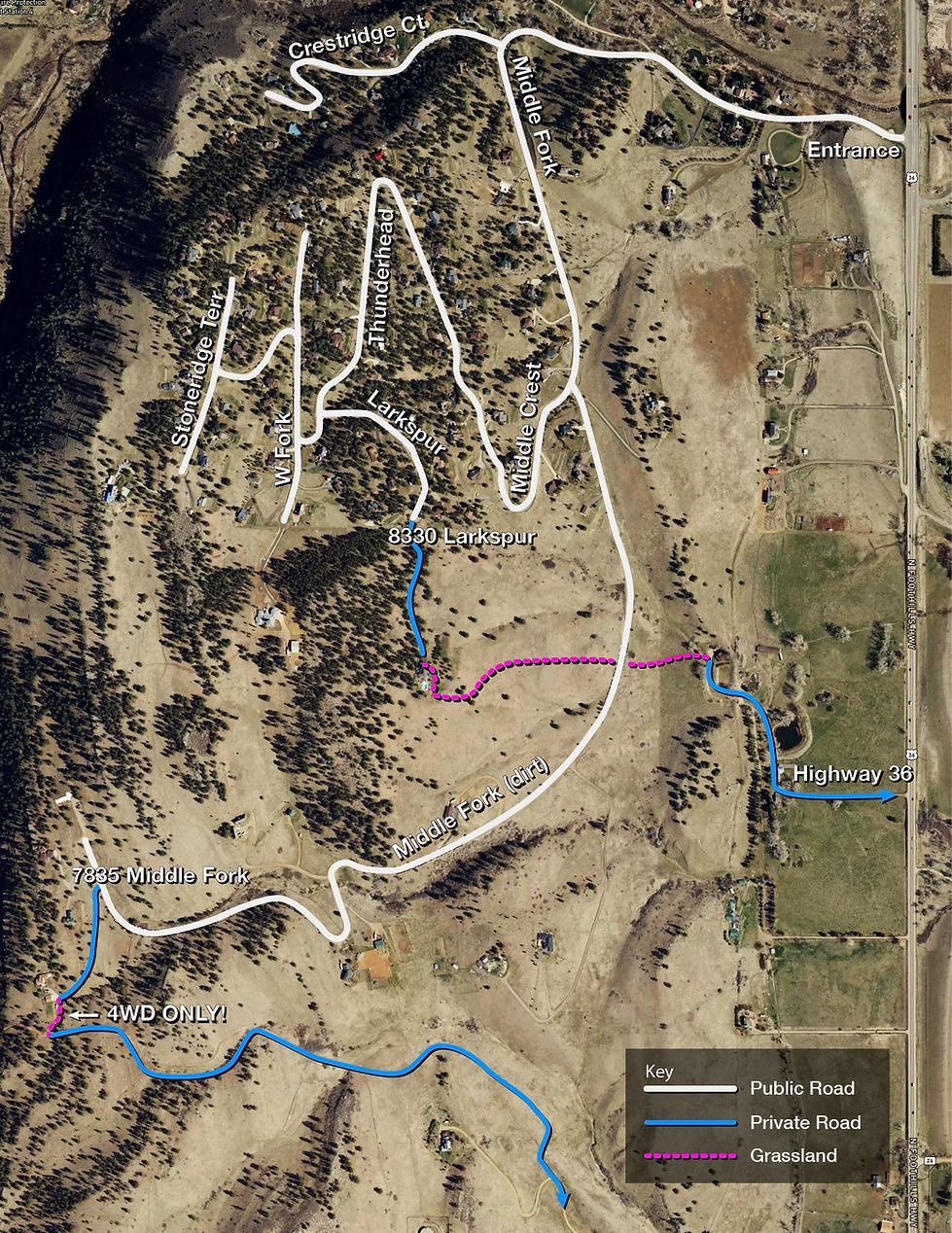
Print this map
It is a good idea to have a print-out by the door for residents, guest, house sitters, etc.
Download map in .PDF format.
Our Risk
Boulder County is considered one of the top 10 most at‐risk areas for wildfire in the USDA Rocky Mountain Region.
-
The county’s “Fireshed” concept recognises that wildfires operate across property boundaries and at large scale.
-
Because of steep slopes, dense forest and grasslands, and “wildland-urban interface” communities (homes adjacent to open space), the risk is elevated.
-
Understanding that it’s not if a major wildfire happens, but when, helps motivate good preparation.
Community Plan
A Firewise Community
Wildfire safety works best when neighbors work together. Through the Firewise USA® program, Crestview residents are teaming up to reduce wildfire risk, protect homes, and strengthen community connections.
Firewise USA® encourages neighborhoods to take local action—clearing vegetation, improving home hardening, and sharing emergency plans—so every home helps protect the next. By organizing as a Firewise site, Crestview will receive official recognition, guidance from fire experts, and access to grants or mitigation resources.
The Crestview Plan
-
Coming soon!
Mitigate Your Home
Defensible Space, Home Hardening, & Insurance
Humans cause 90 percent of the Wildfires in Boulder County:
-
Accidental: Sparks from machinery, prescribed and agricultural burns, equipment malfunctions
-
Carelessness: Campfires, cigarretes, or fireworks
-
Purposeful: Arson and other malicious intent
Defensible Space + Home Hardening
-
Study: Home hardening can more than double chances of homes surviving wildfires
-
The Wildfire Partners program (by Boulder County) offers home assessments, guidance, mitigation support for homeowners. Start here with a free assessment.
-
If you need assistance, contractors can help. The Boulder Fire Ready group is an example and provides one-stop coordination of vegetation management, home hardening, and defensible space services.
-
The Boulder County Mountain Addressing System is designed to expedite emergency response. It is important that you clearly display the “green” address plate at your entrance. See Mountain Addressing System, and this article on how to place an order (coming soon).
Insurance
-
Insurance Check: Make sure your homeowner’s insurance covers wildfire risk, understand your policy.
-
Details on insurers coming soon.
Emergency Plan
Build Your Plan
-
Communication Plan: How will your family or household stay in touch? Where will you meet if separated? What’s the out-of‐area contact?
-
Practice & Review: Do a drill with your household. Review annually. Update for new conditions (kids, pets, medical needs).
Grab List & Kit
-
Grab List & Kit: See above—emergency kit for home, car, pets. Make copies of important documents, photo inventory of your possessions.
-
Emergency Kits – Boulder ODM – guidance on what to pack.


Emergency Alerts– Sign up today!

BoCo Alert System Signing up for an Everbridge opt-in account (reverse 911) enables you to receive emergency alerts. Additionally, you will receive tornado and flash flood warnings too.

Watch Duty – Real-time wildfire maps, alerts, prescribed burns, fire perimeters, and evacuation orders.
Fire, Smoke, Air

Thunderhead Dr Monitor to look up the fine particulate matter in Crestview.

AirNow Fire and Smoke map indicates where our smokey air is coming from. Turn on NOAA Smoke Plumes by clicking the gear icon.

Air Quality Aware give the current and forecasted conditions.
Floods

Overview of Floodplain management in Boulder County, and a detailed Boulder County Flood Plane map. Turn on FEMA layers.
Boulder County

Wildfire Partners is a key Wildfire mitigation partner with Crestview. Programs include: Free Individual Home Assessment, Community mitigation, Community Chipping, $ Rebate Programs, and more.

Boulder County – Preparing for a Wildfire county-wide information and Personal Wildfire Action Plan tools, Mitigation Programs and local Wildfire History.